Beaver Creek Regional Council ~ P.O. Box 939 - Rimrock, AZ 86335 ~ Council@BeaverCreekAZ.org ~ Webmaster - E-Klectic Solutions


Serving the Beaver Creek Communities of Lake Montezuma ~ Rimrock ~ McGuireville of Arizona
Beaver
Creek
Regional
Council

Water Resource Committee
The purpose of the Water Resources Committee is to participate in research, planning and coordination of water resources and water use in the Communities of Beaver Creek and represent Beaver Creek’s position in Verde Valley water initiatives.


COMMITTEES SEEKING ACTIVE MEMBERS
If you have an interest in water resources, the future of our Beaver Creeks and sustainable water use in the Verde Valley and Beaver Creek, the Water Resource Committee of BCRC would love to hear from you. Contact Kala Pearson to sign up - Kala_Pearson@BeaverCreekAZ.org
Forums & Workshops
If you would like to sponsor or conduct a forum or workshop on water resources - adjudication - well and septic care or other water related interest, please contact the Council at Council@BeaverCreekAZ.org
Holocene Alluvium Report for Wet Beaver Creek


Chairperson:
Patricia Olsen
Members:
Karin Krippene
Rose Mary Barnes
U. of A. Extension
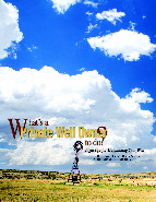
Well Owner’s Guide to
Ground Water Resources in Yavapai County


Adjudication
Arizona Dept of Water Resources Database

USGS Stream Gauges
After nearly a yearlong struggle, the U. S. Geological Survey has found partners to fund 41 stream gauges statewide, including the bulk of the main ones in the Verde Valley, that were dropped by the Arizona Department of Resources, due to funding cuts last October.
Yavapai County Flood Control District has taken over funding for the Clarkdale Gauge, Granite Creek below Watson Lake, Oak Creek at Sedona and Oak Creek at Cornville. Salt River Project, which funds 20 gauges statewide, has agreed to fund the Wet Beaver Creek, Dry Beaver Creek and East Clear Creek and the Verde River gauge below Camp Verde gauges. ADWR will fund the Del Rio Springs gauge.
YES... Add me to your mailing list for eNEWS and newsletters
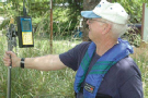
Residents of the Beaver Creek are served by private wells or private water companies and septic systems or private wastewater treatment facilities. There are private ditches in the area that are used for irrigation – primarily on ranches and the golf course.
The Beaver Creek communities are within the Verde River Watershed of which Wet Beaver Creek, Dry Beaver Creek, and Beaver Creek are important tributaries to the Verde River. Groundwater in the area is located in subsurface basins composed of alluvial material or broken sedimentary material and is strongly relied upon to supply potable water for domestic or commercial use. This reliance is mainly due to existing surface water agreements with the Salt River Project and because of the ease of obtaining groundwater water as opposed to surface water.
The subsurface basins (aquifers) are recharged by surface irrigation, rain, wastewater effluent disposal or by underground flows into the area. The Verde Formation and Quaternary Alluvial Aquifers (VFQA), flowing southeast and the “Carbonate” Aquifer, flowing from the mountains to the east generally in a southwesterly direction are the main aquifers for the area.
News
Wastewater
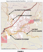
Dry Beaver Creek Floodplain Delineation Study
The Yavapai County Flood Control District, in conjunction with Southwestern Environmental Consultants, Inc. (SEC), is performing a hydraulic modeling project for a portion of Dry Beaver Creek from the confluence of Wet Beaver Creek to approximately 5 miles upstream (see Figure 1) within the unincorporated area of Yavapai County, Arizona, adjacent to the community of Lake Montezuma.
The purpose of the Dry Beaver Creek Floodplain Delineation Study is to identify the floodplain area of Dry Beaver Creek by performing a detailed hydraulic analysis of those areas prone to flooding during the 1 and 0.2-percent annual chance (100- and 500-year) storm events. In addition, the basin study will provide guidance to the County in implementing floodplain management in a logical, cost-effective manner.
Krishan Ginige P.E., SEC Inc.
825 Cove Parkway Cottonwood, AZ 86326
Telephone: 928-634-5889 Ext. 2022
E-mail: krishan(sec-landmgt.com
Beaver Creek Floodplain
Floodplain
![]()
![]()
Water Resource Links
Yavapai County Flood Control District ALERT System
Floodplain or Flood-prone areas are areas adjoining the channel of a watercourse including areas where drainage is or may be restricted by man-made structures which have been or may be covered partially or wholly by floodwater from the one hundred-year flood. Floodplain management programs exist for corrective and preventive to reduce flood damage, including but not limited to emergency preparedness plans, flood control works and floodplain management regulations.
EMERGENCY
PREPAREDNESS
“Better Safe Than Sorry”
Contact the
Montezuma Rimrock Fire
District for local plan info
928 567-7428
Reclaimed Water (Effluent Reuse)
Reclaimed water is wastewater that has been treated to a standard that will allow its use in irrigation, water features, and golf course lakes. The area has one wastewater treatment facility built to service the Beaver Creek Preserve development. A future development, Indian Lakes I has a permit to build a waste water treatment facility. The reclaimed water from this future facility will be used for landscape and golf course irrigation.
Individual may chose to use gray water collected from showers, washing machines, and bathroom sinks. There are State guidelines on the use of gray water. Follow this link for more information: http://www.graywater.net/
A majority of the Beaver Creek community utilize private septic systems which comprise the greatest amount of wastewater disposal systems in the area. Roughly 90 gallons of wastewater per day per person (gpcd) is generated. With the more moderate weather. The difference between the average water production (120 gpcd) and the estimated wastewater discharge (roughly 85 gpcd in the area) is accounted for by evaporation and lawn and garden irrigation.
The concentration of septic systems in the Beaver Creek area makes the location of new well crucial to avoid contamination. A new well must be located at least 100 feet from the nearest septic system.
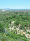
Beaver Creek
The Beaver Creek Watershed is located in the Transition Zone between the Basin and Range and Colorado Plateau regions, centered approximately 80 miles south of Flagstaff. Three major streams define the watershed: Beaver Creek proper, Wet Beaver Creek to the south, and Dry Beaver Creek to the north. Combined, they form one of several Mogollon Rim drainage supplying surface flow to the Verde River. Human communities have depended on this water for more than a thousand years, dating back to the Sinagua. Critical water resources, classic hydrology, rich bio diversity and an ancient history of human settlement make this watershed an irreplaceable resource for education and conservation.
The History of SRPs Claims on the Verde River and Current Legal Issues
Parts 1, 2 & 3
WHAT IS THE GENERAL STREAM ADJUDICATION?
The general stream adjudication is a judicial proceeding to determine or establish the extent and priority of water rights in the Gila River system. Claimants and water users are joined in these proceedings that will result in the Superior Court issuing a comprehensive final decree of water rights... more

Join the Verde Valley Water Users, Inc.


National Weather Service - Lake Montezuma, AZ
FEMA - U.S. Federal Emergency Management Agency
National Flood Insurance Program
Yavapai County Flood Control District
Yavapai County Water Advisory Committee Reports:
Click logo to link to report